Streambank stabilization on the Crystal River
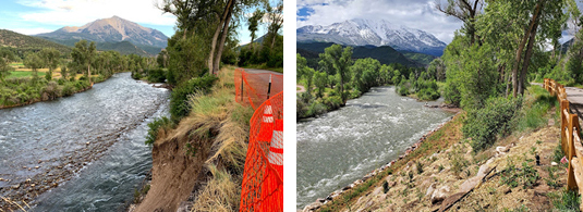
Before (left) and after the stabilization project.
Pitkin County’s Open Space and Trails program is wrapping up a significant riparian restoration project on the Crystal River just above the Thomas Road Bridge.
Significant erosion of the steep streambank occurred in 2019 as a result of extended high flows on the Crystal River. The resulting bank failure cut back to the edge of the Crystal Trail and an irrigation ditch that is piped beneath it. The resulting vertical drop to the river exposed loose soils that would have continued to erode and ultimately threatened Highway 133.
Since the construction of the Crystal Railroad in 1893, the banks of the river have been continually armored by riprap to protect the myriad roads, driveways and highway that now bracket the river in many locations. While bare riprap does protect road structures, it is ecologically sterile, and degrades both aquatic and riparian habitat. Rather than simply re-armoring the problem area, Pitkin County Open Space and Trails opted to stabilize the steep bank with a bio-engineered approach. While more expensive than the typical riprap, the bio-engineered strategy was chosen to help restore the physical landscape, ensuring long-term stability and enhancing the riparian zone and ecological function of this area. The project addressed the critical zone of erosion and extended on both sides of the critical zone to tie in the new hillslope to the pre-existing intact streambank.
The open space design consists of 3 basic components:
- A boulder revetment and floodplain deck/wetland restoration zone that defines the river channel and prevents migration back toward the highway while also serving to disperse the river’s energy when flows get high enough to overtop this floodplain “bench.” This area contains wetland plantings and willow stakes that had a great success rate this spring.
- A riparian restoration zone, transitioning the floodplain bench to the upland hillslope. A targeted seed mix and riparian plants (cottonwood, dogwood, alder, willow, etc.) were planted here with erosion-control matting and a temporary irrigation system to help ensure plant establishment and seed germination. Once established, this zone will provide long-term erosion control naturally, and riparian habitat and connectivity where there was none before!
- The upland restoration zone. A large amount of fill was required to address the steep critical zone of erosion, and then the careful placement of boulders and large native logs into the hillslope created a more organic look and function. The microclimates created by these boulders and logs are beneficial for dryland seed and upland plant establishment (sagebrush, serviceberry, antelope bitterbrush, etc.). These local materials and the ecologically oriented design are not only more aesthetic than traditional riprap, they will also contribute to long-term bank stability and create more native habitat.
Pitkin County was assisted in this bio-engineering designed by SGM and DHM, and the delicate in-river construction was handled by Gould Construction, with SPI providing the restoration landscaping. The project was also supported by Bill Fales and Cold Mountain Ranch.
By Pitkin County Open Space and Trails